4th European Conference on Underwater Acoustics
Rome, Italy, 21 to 25 September 1998
UNDERWATER TRAJECTOGRAPHY SYSTEM FOR MEASUREMENT OF SUBMARINE RADIATED NOISE.
C. Noel - C. Viala(1) G. Goullet - M. Alombert (2) O. Gérard (3)
(1) SEMANTIC TS. 39 Chemin de la Buge 83110 SANARY. FRANCE
(2) DGA/DCE/CTSN BP 28 83800 TOULON NAVAL. FRANCE
(3) ANALIS Imm Arep Centre, Traverse des Brucs, 06560 VALBONNE. FRANCE
1. INTRODUCTION
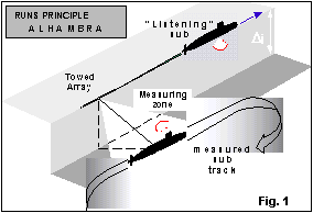
DGA, the French technical organisation of the Ministry of Defence, has developed a new system in order to measure the radiated noise of submarines. This system named ALHAMBRA uses a calibrated linear array, towed by a submarine which also supports the recording apparatus. Later on, a towing surface ship should be used. ALHAMBRA is an operational system.
In the measurement scheme (Fig.1), the towing submarine follows a straight uniform track, and the measured submarine performs a run parallel to the array. The high performance array processing requires the track to be within a predetermined area. In this area, the submarine position relative to the array must be known permanently with a high reliability and a given accuracy, fitting the processing requirements. The system must also ensure the safety of the operation, during the run itself (measurement phase) and during the presentation and turning after the runs phases.
|
|
 |
Reciprocally, the measured submarine needs some information about her position relative to the array and to the towing ship, to allow for correct steering (Fig.2). The same kind of technique combined with an azimuth measurement is used for this other function. These functions have been fulfilled with an acoustical range measuring technique described hereafter.
|
2. SYSTEM DESIGN REQUIREMENTS.
The main constraint for this project was the lowest cost possible. This led to chose the simplest solutions at every stage of system design. Many other points have been determined by this constraint.
2.1- Accuracy, range, recurrence.
A low measurement threshold was the first goal. Reaching this goal required the choice of a sophisticated array processing technique, which, conversely, implied a high accuracy knowledge of the measured submarine position relative to the array.
The required accuracy for the position during the measurement phase was 25 cm standard deviation.
The largest distances to be considered are 3 km .
The more frequently information are provided, the better.
2.2- Acoustic contamination.
As the range measuring technique is acoustical, the acoustic contamination of the radiated noise measurement must be negligible for frequencies < 10 kHz, or as limited as possible for higher frequencies.
2.3- Use of at sea proved techniques. Reliability
To date, range measuring techniques are thoroughly used on French noise ranges. Measurement hydrophones are used also for the distance measuring system, providing the distances really needed without any unwanted bias.
For the whole set of environments, a high reliability is required for the trajectographical or position information, given the safety requirements and the short time span usually devoted to the measuring operation.
2.4- Relative speeds
The speed of the measured submarine is higher than the towing speed.
The system must be operating for the whole relative speed range.
3. DESIGN CONSIDERATIONS – PRINCIPLES
 |
Previous systems, and noise range experience lead to chose a synchronised time of propagation technique, which require high stability clocks on both submarines. The basic principle is shown in figure 3 : a given acoustic signal is radiated by the measured submarine at fixed predetermined times. The reception of this signal allows the measurement of the propagation time, which is related to the distance between the transmitting and receiving points. Some requirements have to be met: relatively short distances, limited velocity gradient... Some requirements are in contradiction, so best trade-off must be found. |
For instance, the low acoustic contamination requirement induces a low source level, which gives a high false alarm rate, and is not compatible with long range. The accuracy needed is antagonist with the relative speed range.
So, the design has to deal with 4 signal parameters :
• signal type or waveform • emitting level
• signal duration • recurrence
As the measuring bandwidth is 20 kHz, the range measurement signal must be within this frequency range.
4. DISTANCE MEASUREMENTS
4.1- Signals parameters: waveform, band, duration, recurrence.
|
First
matched filtering, optimal type of processing in that kind of application [1] [2]
is used bringing a gain proportional to BT product (signal bandwidth-duration).
Minimal bandwidth used is 4 kHz to achieve accuracy. A duration of about 100 ms
is necessary to yield gain and reliability. Signal waveform must allow to deal
with Doppler problem due to relative speed of submarines.Among Doppler shift
resistant signals which are frequency modulated, one type is used by
Pipistrelle Nathusii bats during acceleration stage or obstacle avoidance
action [3].This signal appeared to be adapted to our problem. An example of
temporal representation of that kind of signal is given on Fig. 4. Its
analytical form is :
|
Fig. 4 |


Doppler shift leads to a certain bias on the distance measurement which could be a problem with the required accuracy. But in the present case, this accuracy is needed mainly within the measurement area, where the measured submarine is abeam of the array i.e. when the relative speed vector is nearly perpendicular to the transmitter-hydrophone line. The remaining bias is also reduced by the multiple point positioning principle.
4.2- Source level, Sonar equation
Source level is the result of a compromise : low enough for a linear response of receivers (required condition to get matched filtering theoretical gain) and low contamination, and high enough for range and reliability. A signal to noise ratio figure of 15 dB provided sufficient reliability, from at sea experiments. Maximal range is determined for sea state 5 and maximal frequency used (20 kHz). Classical sonar equation gives then source level. Surface echo problem has been reduced with time windowing techniques. Given the maximum range, the recurrence has been set to 2 s
5. POSITIONING SYSTEM
5.1- Notations and configuration
Configuration is given in the plane defined by array axis and submarine position :
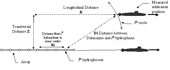
Fig. 5 : Notations and configuration
5.2 Positioning equations
Each measured distance Di between submarine emitting transducer and a certain number of hydrophones satisfies:
![]() for i = 1 to 8 (1)
for i = 1 to 8 (1)
Each Di associated with Ri, places submarine on a circle of which characteristics are
(centre : ith hydrophone ; radius : Di). Taking A = R2 + Z2 and B = -2 R (2)
then ![]() for i =
1 to 8 (3)
for i =
1 to 8 (3)
Looking for optimal coefficients (A and B) over measurements ensemble, penalty function is:
![]() (4)
(4)
|
which would represent distance variance over Ri ensemble if wi values have been unity. Problem is then to find A and B which minimise this cost function viz. satisfy the system (5) :
|
|

which is equivalent after development to :
|
|

| Using the following notation : |
| to describe weighted mean of X measurements (which can be Ri, Ri2, Ri3, Di, Di2, Di3), we get a linear system for A and B : |
|

Solutions are :
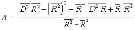
 (9)
(9)
| Knowing spatial
positions of array hydro-phones ( |
|
5.3- Positioning system principle
Main stages of positioning system process are :
For each distance measuring system recurrence:
Stage 1: • 8 distance acquisition relative to selected array hydrophones of known abscissa
Stage 2: • Check distances coherence : filtering of each hydrophone distance « history », reject extraneous points
Stage 3: • Computation of (R, Z) position with 8 (or less) hydrophones distances
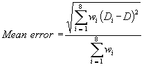
• Mean error computing :
• Test on error value compared with the admissible error
• Elimination of hydrophone until they remain 3 and error is decreasing
• If final error is less than admissible error : solution (R, Z) - mean error
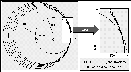
Following figure shows 8 circles and positioning results. In that case the X1 hydrophone has been put apart from the others, equally spaced or not.
5.4- C.P.A. predictions
When positioning system has been solved N times, N measured points are determined [(R1,Z1), (R2,Z2), ... , (RN,ZN)] from which we can estimate mean speed vector. Assuming trajectory to be rectilinear, the problem is to find best coefficients (Ra,Za,Vr,Vz) satisfying the following system over the N positions ensemble :
|
|
where t is time, (Ra, Za) is position at t=0 and (Vr, Vz) is mean speed vector (11) |

| Cost function in that case is : |
|
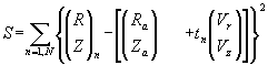
Minimising cost function over the N positions set gives (Ra,Za,Vr,Vz) from which CPA time and distance are derived :
| For R= 0 : |
|
For t = tCPA : |
|
So CPA position and time can be predicted and provided to the navigation officer. CPA prediction and submarine position are used to control automatically the recording system.
6. TRAJECTOGRAPHY SYSTEM
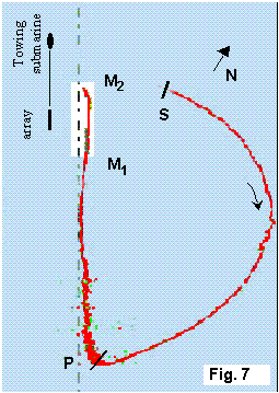 |
Trajectography is defined by positions (R, Z) set at each temporal recurrence. One real example is given on figure 7, which shows a quasi complete operation: return [S-P], presentation[ P-M1] and measuring phase [M1-M2]. |
7. CONCLUSIONS
The developed system for trajectography and positioning proved satisfactory:
• observed ranges were over the requirements : 6000 m in normal environments were obtained.
• accuracy is higher than expected: 15 cm error standard deviation or bias was observed by checking at sea by the range measuring system itself the (known) hydrophone positions when transmitting from the towing submarine.
• reliability is high enough to deliver the requested information for array processing
• in good environmental (ambient noise) conditions the source level used is low enough to keep the acoustic contamination within an acceptable level.
8. REFERENCES
[1] J. MAX : Méthodes et techniques de traitement du signal. Tome 2. 4éme Ed. 1987
[2] P. ARZELIES et al: Système de navigation base longue à traitement cohérent. 3ième Colloque sur la localisation en mer, Rueil Malmaison, 1987.
[3] R.A ALTES: Methods of wideband signal design for Radar and Sonar environment. Ph. D. Rochester 1970.
[4] M. BOUVET: Traitement des signaux pour les systèmes sonar. Masson 1992